


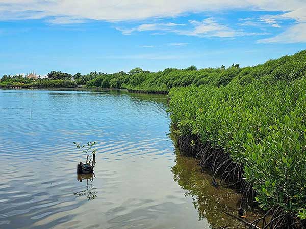
The Department of Environment and Natural Resources (DENR) is pioneering disaster risk reduction by rolling out a citizen science program. Spearheaded by DENR Secretary Maria Antonia Yulo-Loyzaga, this program aims to manage and protect the Philippines’ vital mangrove cover as part of the BakaJuan project, with volunteers and stakeholders actively implementing it.
The agency reported a reduction of the Philippine mangrove forests from 450,000 hectares in 1918 to 303,373 in 2015. Recognizing an urgency, the DENR and the Philippine Space Agency (PhilSA) established the Nationwide Mangrove Mapping initiative, which utilizes the National Mangrove Map 2023, a satellite-derived map designed to detect and validate mangrove cover in the country.
Secretary Yulo-Loyzaga has emphasized the power of citizen science in the initiative, urging public participation in tracking and protecting mangroves. Individuals can use the ODK Collect app to verify the presence of mangroves in coastal barangays and send drone-taken photographs to PhilSA.
Citizen scientists called “BakaJuan” volunteers are critical to the project’s success. “Amid the climate emergency and destruction of mangroves, everyone has the ability to make a difference by tracking and protecting our natural resources,” Yulo-Loyzaga said.
As of May 22, 2024, 81 percent of the soft target—4,955 out of 6,110 validation points—has been met, rising to 95 percent on May 26, 2024, with 5,828 entries. DENR hopes to finish the field validation of over 600 sites and 30,000 validation points around the country by June 2024.
But days shy of the target schedule, the Department, through a post on its official Facebook page, has announced a 100% completion rate of its 6,000 soft target. The milestone is only Phase One of the campaign. Further announcements shall be made by the Department to kick off the campaign’s Phase Two.
According to the DENR, validating the National Mangrove Map is critical for appropriately assessing the country’s natural resources, which contribute to climate resilience and sustainable development. This endeavor is consistent with Secretary Yulo-Loyzaga’s appeal to “measure what we treasure,” and the government’s dedication to protecting vital ecosystems is in line with this endeavor.
President Ferdinand Marcos Jr. himself recognizes the importance of mangrove preservation, describing it as a “very big” issue. “It is a very important point for the Philippines because of all the waterways that we have,” he said.
Under Threat, But Hope Remains
The Philippines’ coastlines thrive with a unique ecosystem: mangroves. The country has 35 kinds of these salt-tolerant trees, mostly located in Palawan and Sulu, according to state think tank Philippine Institute for Development Studies (PIDS). But mangroves are more than just coastal flora; they are the Philippines’ natural protection against typhoons.
This archipelago is frequently battered by storms. In 2013 alone, Super Typhoon Yolanda killed over 6,000 people and cost $2 billion in damages.
Here’s where mangroves come in: World Bank’s WAVES Program report emphasized its importance in reducing flood threats. According to the report, mangroves provide communities with protection from the worst of storm surges and typhoons, with its trunks and canopies lessening the effects of waves and storm surges, reducing floods; its aerial roots stabilizing sediments, avoiding erosion.
With the possibility of a La Niña phenomenon looming in the country, foreseen to bring stronger winds and heavy rainfall, healthy mangrove forests become even more crucial. State weather bureau Philippine Atmospheric, Geophysical, and Astronomical Services Administration predicts a 62 percent possibility of La Niña emerging between June and August this year.
To address the diminishing coverage of the country’s mangrove forests, the BakaJuan campaign requires the feasible and relevant participation of the people to help arrest the decline, an endeavor that reflects the Marcos administration’s “whole-of-society” paradigm in nation-building.
The DENR, led by Yulo-Secretary Loyzaga, spearheads the mindset for building the country’s resilience to climate change’s extreme weather impacts. The Department encourages more volunteers to join the campaign.
More Science-Based Initiatives
This BakaJuan project complements existing science-based projects led by the DENR to improve disaster resilience and management throughout the country.
It recently launched Project TRANSFORM, a multi-stakeholder initiative empowering communities to combat climate change and achieve sustainable development. This project has been implemented in several locations, including Ormoc City in Leyte, and various towns in Surigao del Norte, Bataan, Rizal province, and Quezon City.
DENR Secretary Loyzaga also worked with local executives to integrate hazard maps into decision-making, thereby averting disasters and protecting lives and livelihoods. “A hazard does not have to become a disaster,” Loyzaga said, emphasizing the need for data-driven indications for early warning and response, such as the exceptionally heavy rainfall.
To promote early disaster readiness, the DENR, through its Mines and Geosciences Bureau, regularly updates hazard maps and conducts information, education, and communication initiatives. The agency provides tailored geohazard advisories for local governments and barangays.
By utilizing hazard maps and advisories, the DENR also collaborates with the Office of Civil Defense to improve the country’s disaster risk reduction and management program by promoting proactive disaster preparedness.
DENR’s science-based initiatives demonstrate a comprehensive approach to disaster resilience, bringing together the government, communities, the private sector, and individuals in efforts to protect the environment and reduce the impact of climate change.


