


By Francis Allan L. Angelo
The bustling Iloilo City is grappling with an increasingly alarming issue of land subsidence, which is posing significant risks to infrastructure, economic stability, and public safety.
According to a recent comprehensive study by the University of the Philippines (UP) Resilience Institute, several key districts within the city are sinking at an alarming rate, with some areas experiencing a subsidence rate of up to -9 millimeters per year.
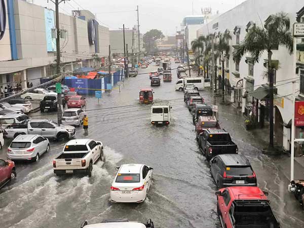
This phenomenon, where the ground gradually sinks, poses serious risks to infrastructure and exacerbates the city’s existing flooding issues, especially in coastal areas.
The study, conducted by the University of the Philippines’ NOAH Center in collaboration with international partners, utilized advanced satellite technology known as InSAR (Interferometric Synthetic Aperture Radar) to monitor ground movement across major Philippine cities from 2014 to 2020.
The Sentinel-1 InSAR data in said years were processed through the LiCSAR system, a product of the UK COMET’s LiCSBAS package. This system automatically generates interferograms, which are then analyzed to detect minute ground movements with millimeter accuracy.
The study specifically focused on vertical ground motion rates in five major Philippine metropolitan areas, including Iloilo City, to provide a comprehensive overview of subsidence patterns across the country.
The findings indicate that the districts of Mandurriao, Molo, and La Paz are among the most affected areas, with subsidence rates of approximately –8 millimeters per year.
The subsidence in these districts is particularly concerning because of their dense populations and rapid urbanization.
Mandurriao and Molo, known for their booming commercial and residential developments, are the hardest hit.
The study warns that this sinking ground could worsen tidal flooding in the City Proper district, where some areas already experience gutter to ankle-deep flooding during high tides, even on sunny days.
La Paz district also shows significant subsidence, raising concerns over the long-term stability of infrastructure and the potential for increased flooding.
The study suggests that excessive groundwater extraction, urban development, and the natural compaction of deltaic sediments are likely contributing to the land subsidence in these areas.
In Molo District, for instance, the intrusion of saline or saltwater into wells has been detected, likely a consequence of over-extraction near the Guimaras Strait.
This issue is particularly worrisome as it not only contributes to the subsidence but also threatens the contamination of the city’s water supply—a problem that could prove difficult to reverse.
In Oton, Pavia, and Leganes (Zones D, E, and F), circular to elongated subsidence of lesser extent and lower rate than Iloilo City ranges from −2.6 to −4.7 mm per year.
FACTORS
According to the study, land subsidence in Philippine metropolitan cities can stem from various natural and human-induced factors.
Where deformation is observed, anthropogenic or human activity disturbs the balance between natural compaction and the support provided by groundwater or other subsurface materials.
Industrial areas, characterized by large structures and high water usage, exhibit significant subsidence rates, particularly in Bulacan, Cavite, and Laguna.
Residential areas with high population growth also experience subsidence, leading to flooding issues exacerbated by climate change-induced sea-level rise.
Structural damage, including fissures and cracks, is evident in residential areas, especially those near fault lines like the Marikina Valley Fault.
In agricultural zones, subsidence results from excessive groundwater extraction for irrigation, while fishponds contribute to subsidence in coastal areas.
Recreational land use, such as golf courses, can also lead to subsidence due to groundwater extraction and land grading. Overall, land subsidence poses significant challenges to urban and rural areas alike, affecting infrastructure, livelihoods, and the environment.
RECOMMENDATIONS
The study recommends that local government units and national regulatory bodies, such as the National Water Resources Board (NWRB), take urgent steps to monitor and manage groundwater extraction more effectively.
It also suggests the continued use of InSAR technology as a long-term monitoring tool, particularly in high-risk areas like Iloilo City, to prevent further subsidence and mitigate its impacts.
The NWRB regulates water wells through the Water Code but faces limitations in monitoring frequency.
In 2013, the Groundwater Management Plan (GMP) preparatory reports suggested regular monitoring, leading to the establishment of monitoring wells nationwide.
However, the current 34 monitoring wells are insufficient, given the numerous registered and unregistered water wells in the country.
The study proposed using InSAR for targeted, long-term monitoring, enabling observation of ground subsidence progression.
Geophysical surveys like seismic reflection and GPR can also analyze subsurface deformation and stratigraphy to determine aquifer types and assess subsidence permanence.
These measures aim to guide groundwater management, land-use planning, and mitigation efforts to prevent excessive land subsidence, especially in faulted areas prone to hazards associated with ground sinking.
For Iloilo City, the findings suggest a pressing need for enhanced groundwater management and land-use planning to mitigate further sinking and its associated risks.


All caused by no town planning, no geological engineering. Iloilo is built on a river delta and the more concrete and people you put on it the more it sinks, very basic engineering.