


Victor Vescovo’s Caladan Oceanic, in collaboration with TCarta and the Greenwater Foundation, has made a significant contribution to ocean mapping by providing detailed seafloor data of the Philippines and Sulu Sea to the Seabed 2030 project. This initiative aims to map the entire seafloor by 2030, addressing the critical need for comprehensive bathymetric data.
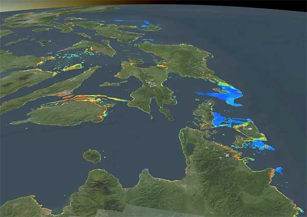
The mapping data, collected using Satellite-Derived Bathymetry (SDB), covers 18,119.84 square kilometers at an average resolution of 10 meters. Some areas were mapped with resolutions as fine as 10 meters, while SDB technology can achieve resolutions as detailed as 0.5 meters for specialized projects. The data was handed over to Dr. Deo Florence L. Onda, a marine scientist at the University of the Philippines, for use in research, hazard identification, and resource management.
Cost-Effective, Eco-Friendly Technology for Coastal Mapping
SDB technology uses satellite imagery to derive seafloor data and offers significant advantages over traditional methods like ship or airplane-based surveys.
“SDB allows us to identify hazards such as channels, sandbars, and reefs, making it essential for safe navigation,” said TCarta CEO Kyle Goodrich. “Its cost-effectiveness and repeatability make it particularly useful for areas like the Philippines and Sulu Sea.”
Unlike traditional methods, which are costly and time-intensive, SDB provides a rapid and low-carbon footprint solution. This is particularly valuable in the Philippines, where tropical storms frequently alter the seafloor, necessitating regular updates to mapping data.
“There are no international restrictions on using publicly available satellite data to create these maps, making SDB an ideal choice for open-source projects like Seabed 2030,” Goodrich added.
Bridging Knowledge Gaps in Ocean Mapping
Despite advancements in marine science, 74% of the global ocean remains unmapped. Victor Vescovo, founder of Caladan Oceanic, highlighted the critical importance of this initiative.
“We have detailed maps of the moon and Mars, yet over half of our planet is unmapped,” Vescovo said. “The ocean is challenging to study and expensive to map. By leveraging technology like SDB, we can reduce costs and finally start understanding what lies beneath the surface.”
The lack of detailed underwater topography hampers marine resource management, navigation safety, and environmental conservation. At the time of the Seabed 2030 project’s launch in 2017, only 6% of the ocean was mapped to adequate resolution. This figure has since improved to around 26%, but the gap remains significant.
Commander G. Mark Miller, co-founder of the Greenwater Foundation, emphasized the urgency of addressing this knowledge gap. “You can’t manage resources, understand ecosystems, or navigate the ocean safely without knowing what’s there,” he said. “This collaboration demonstrates how cutting-edge technology can advance our understanding and protection of marine environments.”
Benefits to the Philippines and Global Marine Science
The contributed data provides immediate benefits to the Philippines by enhancing awareness of potential coastal hazards, improving fisheries management, and supporting scientific research. Coastal hazards like uncharted reefs and sandbars pose risks to navigation and safety, issues that SDB can address efficiently.
“By reducing costs through artificial intelligence and leveraging open-source data, we can map even the most inaccessible or dangerous areas,” Miller added. “This is crucial for understanding and protecting coastal ecosystems, particularly biodiversity-rich regions like the Sulu Sea.”
The initiative also aligns with the Philippines’ growing focus on marine conservation and resource management. The Sulu Sea, known for its rich biodiversity, is critical to the country’s ecological and economic stability.
Seabed 2030’s Role and Global Implications
Seabed 2030, a partnership between The Nippon Foundation and GEBCO, plays a pivotal role in coordinating global efforts to map the seafloor. Data contributions from projects like this one feed into a freely available global grid maintained by the IHO Data Center for Digital Bathymetry.
“This collaboration exemplifies how satellite-derived bathymetry can significantly expand our knowledge of unmapped coastal areas,” said Jamie McMichael-Phillips, director of Seabed 2030. “We are grateful for this invaluable contribution, which brings us closer to realizing a complete map of the seafloor by 2030.”
The project showcases the potential of partnerships between governments, non-profits, and private entities to address global challenges. By making these maps freely available, Seabed 2030 promotes equitable access to marine data, fostering collaboration across scientific and environmental communities.
About the Key Players
Caladan Oceanic, led by Victor Vescovo, is a marine technology company based in Texas. The firm has pioneered deep-sea exploration, including mapping over three million square kilometers of seafloor during expeditions from 2018 to 2022. All data collected has been contributed to the Seabed 2030 project.
Denver-based TCarta specializes in geospatial and hydrospatial data services. As a global leader in satellite-derived bathymetry, TCarta offers innovative solutions for near-shore mapping, bridging gaps between traditional surveys and open-source data.
The Greenwater Foundation, founded in 2023, is a US-based non-profit that supports ocean scientists by providing access to research vessels and other essential resources. Its focus areas include coastal mapping, marine conservation, and education.
Seabed 2030, launched at the 2017 United Nations Ocean Conference, is a collaborative effort to map the global ocean floor. By compiling and distributing bathymetric data, it supports sustainable marine resource management and disaster risk reduction.
Looking Ahead
With the completion of this project by December 2024, stakeholders hope it will serve as a model for future initiatives. The Philippines and the Sulu Sea now have access to high-quality seafloor data that can inform policies, scientific studies, and conservation efforts.
“This is just the beginning,” Vescovo said. “Through partnerships and technology, we can achieve the ambitious goal of mapping the entire seafloor by 2030. The ocean may be hard to study, but it’s not impossible—and its protection is more important than ever.”